Probe and ponder
1 Why are winds stronger on some days than on others?
Solution
Wind is simply air that is moving from one place to another. Air moves whenever there is a difference in air pressure between two nearby regions — it flows from the region of higher pressure to the region of lower pressure.
The speed (strength) of the wind depends on how big this pressure difference is:
- If the difference in pressure between two regions is large, air rushes from the high-pressure region to the low-pressure region very fast, producing a strong wind.
- If the difference in pressure is small, air moves slowly and we feel only a gentle breeze.
The pressure difference itself is created by uneven heating of the Earth's surface by the Sun. On some days, the Sun heats certain regions much more strongly than others (for example, land heats up faster than a nearby sea). This creates a large pressure difference and hence strong winds. On other days the heating is more uniform, the pressure difference is smaller, and the winds are weaker.
Answer
2 Why are water tanks usually placed at a height?
Solution
Water is a liquid, and a liquid at rest exerts pressure on the walls and base of the container that holds it. This pressure increases as the depth of water increases — the deeper you go, the more the weight of the water above pushes down.
When a water tank is placed on the roof of a building, every tap connected to it is much lower than the water surface in the tank. So the water inside the pipes is under a large pressure created by the tall column of water sitting above the tap. When we open the tap, this pressure pushes water out with a strong, steady stream — strong enough to reach all the taps in the house and to run showers, washing machines and flush cisterns.
If the tank were kept at the same level as the taps, the height of the water column above the taps would be very small, the pressure would be very low, and water would only trickle out (or not flow at all). Placing the tank at a height ensures a good gravity-driven pressure without needing an electric pump to run all the time.
Answer
3 Can air pressure really crush us?
Solution
The Earth is surrounded by a thick blanket of air called the atmosphere. This air has weight, and the weight of all the air above us pushes down on every square centimetre of our body. This push per unit area is called atmospheric pressure, and it is surprisingly large — about $$1{,}00{,}000 \, \mathrm{N/m^2}$$ at sea level. That means every square centimetre of skin is being pushed on by roughly the weight of a $$1 \, \mathrm{kg}$$ mass!
With such a huge force acting on us, why aren't we crushed?
The reason is that atmospheric pressure does not only push from outside. The air, fluids and gases inside our body (in the lungs, blood, tissues, ears, etc.) push outward with exactly the same pressure. The inward push of the atmosphere and the outward push from inside balance each other perfectly, so the net force on us is zero and we feel nothing.
So air pressure is strong enough to crush a sealed empty can (as you can show by heating a can, sealing it and cooling it), but it cannot crush us as long as the pressure inside our body equals the pressure outside. If the balance is disturbed — for example, if you climb a mountain quickly and the outside pressure suddenly drops — you can feel discomfort in your ears, but even then the inside pressure quickly adjusts.
Answer
4 What causes storms and cyclones? If the Earth stopped rotating, would cyclones still form?
Solution
What causes storms and cyclones?
Storms and cyclones are caused by uneven heating of the Earth's surface, which creates strong differences in air pressure.
- When the Sun heats a region strongly (especially warm sea water), the air above it becomes hot, less dense and rises upward. This leaves behind an area of low pressure near the surface.
- Cool, moist air from surrounding high-pressure regions rushes in to fill this low-pressure region. This rushing air is wind.
- The rising warm, moist air cools at higher levels, water vapour condenses into water droplets, and huge amounts of heat stored in the vapour (latent heat) are released. This extra heat makes the air rise even faster, pulling in more surrounding air. A powerful cycle sets up, giving rise to strong winds, thunderclouds and heavy rain — a storm.
- Over the warm oceans, this cycle can grow into an enormous, organised, whirling system of very strong winds (typically more than $$120 \, \mathrm{km/h}$$) called a cyclone.
Would cyclones still form if the Earth stopped rotating?
The Earth's rotation is what makes the rushing winds spin around the low-pressure centre (through what is called the Coriolis effect). It is this spinning motion that gives a cyclone its familiar swirling, wheel-like shape with an 'eye' at the centre.
If the Earth stopped rotating, thunderstorms with strong winds and heavy rain would still form (because uneven heating and rising moist air would still happen), but they would not whirl around a centre. In other words, storms would still occur, but true rotating cyclones would not form.
Answer
In-Text Questions
5 Suppose you are living on the second floor of a three-storeyed building and an overhead water tank is placed on the top floor. Will you or your friend on the first floor receive a more powerful stream of tap water? Give reasons.
Solution
The overhead tank is on the top (third) floor. When we open a tap, water flows out because of the pressure created by the column of water standing above that tap. The taller the column of water above a tap, the greater the pressure and the more powerful the stream.
Comparing the two taps:
- The tap on the second floor is only one floor below the tank, so the column of water above it is short — the pressure at the tap is small.
- The tap on the first floor is two floors below the tank, so the column of water above it is taller — the pressure at the tap is larger.
Using the idea that liquid pressure increases with depth, we can write $$P = h \rho g$$, where $$h$$ is the height of the water column above the tap. Since $$h$$ is bigger for the first-floor tap, the pressure $$P$$ (and hence the speed with which water gushes out) is bigger there.
Therefore, my friend on the first floor will receive the more powerful stream of tap water.
Answer
Keep the curiosity alive
1

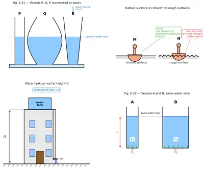
(i) Look at Fig. 6.21 carefully. Vessel R is filled with water. When pouring of water is stopped, the level of water will be ________.
(a) the highest in vessel P
(b) the highest in vessel Q
(c) the highest in vessel R
(d) equal in all three vessels
Solution
Fig. 6.21 shows three vessels P, Q and R of different shapes joined at the bottom by a common tube. This is a set of communicating vessels.
A liquid at rest exerts pressure that depends only on the depth (height of liquid column) and not on the shape of the vessel. So water will flow between the vessels through the joining tube until the pressure at the bottom is the same everywhere. This happens only when the height of the water column above the connecting tube is the same in every vessel.
Therefore, whatever be the shape or width of P, Q and R, once pouring stops water settles at the same level in all three vessels.
The correct option is (d) equal in all three vessels.
Answer
(ii) A rubber sucker (M) is pressed on a flat smooth surface and an identical sucker (N) is pressed on a rough surface:
(a) Both M and N will stick to their surfaces.
(b) Both M and N will not stick to their surfaces.
(c) M will stick but N will not stick.
(d) M will not stick but N will stick.
Solution
A rubber sucker works by trapping no air between itself and the surface it is pressed on. When you press the sucker, the air underneath is pushed out. The atmospheric air outside now pushes the sucker hard against the surface with a large pressure ($$\approx 1{,}00{,}000 \, \mathrm{N/m^2}$$), while there is almost no air pressure pushing it away from the surface. This is what makes the sucker stick.
For this to work, the seal between the sucker and the surface must be airtight.
- Sucker M is pressed on a flat, smooth surface. It forms a perfect airtight seal, so no outside air can leak in. Atmospheric pressure holds it firmly in place — M sticks.
- Sucker N is pressed on a rough surface. The tiny bumps and pits of a rough surface leave small gaps through which air can seep in under the sucker. The air pressure below then becomes almost equal to the pressure above, so there is no net push holding the sucker on. N does not stick.
The correct option is (c) M will stick but N will not stick.
Answer
(iii) A water tank is placed on the roof of a building at a height 'H'. To get water with more pressure on the ground floor, one has to
(a) increase the height 'H' at which the tank is placed.
(b) decrease the height 'H' at which the tank is placed.
(c) replace the tank with another tank of the same height that can hold more water.
(d) replace the tank with another tank of the same height that can hold less water.
Solution
The pressure of a liquid at a depth $$h$$ below the free surface is given by $$P = h \rho g,$$ where $$\rho$$ is the density of the liquid and $$g$$ is the acceleration due to gravity.
Notice that $$P$$ depends only on the height of the water column above the tap, and not on how much water the tank holds (i.e. its volume or width).
To get water at more pressure on the ground floor tap, we must make $$h$$ larger. This is done by placing the tank higher — i.e. by increasing the height H. Replacing the tank with a wider or narrower tank of the same height does not change $$h$$, so options (c) and (d) do not affect the pressure. Decreasing H (option b) would only lower the pressure.
The correct option is (a) increase the height 'H' at which the tank is placed.
Answer
(iv) Two vessels, A and B contain water up to the same level as shown in Fig. 6.22. $$P_A$$ and $$P_B$$ is the pressure at the bottom of the vessels. $$F_A$$ and $$F_B$$ is the force exerted by the water at the bottom of the vessels A and B.
(a) $$P_A = P_B$$, $$F_A = F_B$$
(b) $$P_A = P_B$$, $$F_A < F_B$$
(c) $$P_A < P_B$$, $$F_A = F_B$$
(d) $$P_A > P_B$$, $$F_A > F_B$$
Solution
Fig. 6.22 shows two vessels A and B holding water up to the same height. Vessel B is wider (larger base area) than vessel A.
Pressure at the bottom. The pressure exerted by a liquid at depth $$h$$ is $$P = h \rho g.$$ It depends only on $$h$$, $$\rho$$ and $$g$$ — not on the shape or width of the vessel. Since the water level is the same in both vessels, and the liquid and $$g$$ are the same, $$\[P_A = P_B.\]$$
Force at the bottom. Force is pressure times the area on which the pressure acts: $$F = P \times A.$$ For the two vessels, $$F_A = P \times A_A \quad \text{and} \quad F_B = P \times A_B.$$ Vessel B has a larger base area ($$A_B > A_A$$), so $$F_B > F_A$$, i.e. $$F_A < F_B$$.
Hence, $$P_A = P_B$$ but $$F_A < F_B$$. The correct option is (b).
Answer
2 State whether the following statements are True [T] or False [F].
(i) Air flows from a region of higher pressure to a region of lower pressure. [ ]
Solution
Whenever two nearby regions of the atmosphere are at different pressures, air moves from where it is pushed harder (high pressure) to where it is pushed less (low pressure). This moving air is what we call wind. For example, on hot afternoons the air over land becomes hotter, rises, and creates a low-pressure region; cooler air from the sea (which is at higher pressure) then flows towards the land as the sea breeze. So the statement is True.
Answer
(ii) Liquids exert pressure only at the bottom of a container. [ ]
Solution
A liquid at rest exerts pressure in all directions — on the bottom, on the side walls, and even upward on any object dipped in it. This can be shown easily: if we make small holes on the side of a bottle filled with water, water squirts out sideways from every hole, showing that the water pushes outward on the walls too. So pressure is not exerted only at the bottom.
The statement is False.
Answer
(iii) Weather is stormy at the eye of a cyclone. [ ]
Solution
The eye of a cyclone is the calm, circular region at the very centre of the cyclone. Inside the eye, the air is descending gently, winds are very light and the sky may even be clear. The violent winds and thick storm clouds are found in the eye-wall, which is the ring of thunderclouds surrounding the eye, and not inside the eye itself.
So the statement is False — the eye of a cyclone is a calm region, not a stormy one.
Answer
(iv) During a thunderstorm, it is safer to be in a car. [ ]
Solution
A closed metal car is a fairly safe place during a thunderstorm. If lightning strikes the car, the electric current flows along the outside of the metal body (this is called a Faraday-cage effect) and then goes into the ground through the tyres, without passing through the people sitting inside. The people are safe as long as they do not touch the metal parts of the car.
By contrast, standing under a tall tree, in an open field, or near tall metal poles during a thunderstorm is dangerous.
So the statement is True.
Answer
3

Solution
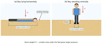
The amount by which the boy sinks into the loose sand depends on the pressure he exerts on the sand, and not just on his weight. Pressure is defined as force per unit area: $$P = \dfrac{F}{A}.$$
In both figures the boy is the same person, so the force he exerts (his weight $$F$$) is the same in both cases. What changes is the area $$A$$ over which this weight acts.
- In Fig. 6.23 a (lying horizontally), the boy's back touches the sand — the area of contact $$A$$ is large. So the pressure $$P = F/A$$ is small.
- In Fig. 6.23 b (standing vertically), only the soles of his feet touch the sand — the area of contact $$A$$ is small. So the pressure $$P = F/A$$ is large.
The greater the pressure, the more the sand grains get pushed apart and the deeper the boy sinks. Since pressure is larger while standing, the boy sinks more in Fig. 6.23 b (while standing) than in Fig. 6.23 a (while lying).
Answer
4 An elephant stands on four feet. If the area covered by one foot is $$0.25 \, \mathrm{m^2}$$, calculate the pressure exerted by the elephant on the ground if its weight is $$20000 \, \mathrm{N}$$.
Solution
Given
- Weight of the elephant, $$F = 20000 \, \mathrm{N}$$
- Area of one foot, $$a = 0.25 \, \mathrm{m^2}$$
- Number of feet in contact with the ground $$= 4$$
Step 1: Find the total area of contact.
Since all four feet are on the ground, the total area over which the elephant's weight is spread is $$A = 4 \times a = 4 \times 0.25 \, \mathrm{m^2} = 1 \, \mathrm{m^2}.$$
Step 2: Apply the definition of pressure.
Pressure is force per unit area: $$P = \dfrac{F}{A}.$$
Step 3: Substitute the values.
$$P = \dfrac{20000 \, \mathrm{N}}{1 \, \mathrm{m^2}} = 20000 \, \mathrm{N/m^2}.$$
\[\boxed{P = 20000 \, \mathrm{N/m^2} = 20000 \, \mathrm{Pa}}\]
So the elephant exerts a pressure of $$20000 \, \mathrm{Pa}$$ (or $$20 \, \mathrm{kPa}$$) on the ground.
Answer
5 There are two boats, A and B. Boat A has a base area of $$7 \, \mathrm{m^2}$$, and 5 persons are seated in it. Boat B has a base area of $$3.5 \, \mathrm{m^2}$$, and 3 persons are seating in it. If each person has a weight of $$700 \, \mathrm{N}$$, find out which boat will experience more pressure on its base and by how much?
Solution
Pressure exerted on the base of a boat is $$P = \dfrac{F}{A},$$ where $$F$$ is the total weight of the people sitting in it and $$A$$ is the base area of the boat.
Boat A
- Number of persons $$= 5$$
- Weight of each person $$= 700 \, \mathrm{N}$$
- Total weight, $$F_A = 5 \times 700 \, \mathrm{N} = 3500 \, \mathrm{N}$$
- Base area, $$A_A = 7 \, \mathrm{m^2}$$
Pressure on the base of boat A: $$P_A = \dfrac{F_A}{A_A} = \dfrac{3500 \, \mathrm{N}}{7 \, \mathrm{m^2}} = 500 \, \mathrm{N/m^2}.$$
Boat B
- Number of persons $$= 3$$
- Total weight, $$F_B = 3 \times 700 \, \mathrm{N} = 2100 \, \mathrm{N}$$
- Base area, $$A_B = 3.5 \, \mathrm{m^2}$$
Pressure on the base of boat B: $$P_B = \dfrac{F_B}{A_B} = \dfrac{2100 \, \mathrm{N}}{3.5 \, \mathrm{m^2}} = 600 \, \mathrm{N/m^2}.$$
Comparison.
$$P_B - P_A = 600 \, \mathrm{N/m^2} - 500 \, \mathrm{N/m^2} = 100 \, \mathrm{N/m^2}.$$
Since $$P_B > P_A$$, boat B experiences more pressure on its base — and it does so by $$100 \, \mathrm{N/m^2}$$ more than boat A.
\[\boxed{P_A = 500 \, \mathrm{N/m^2}, \quad P_B = 600 \, \mathrm{N/m^2}, \quad P_B - P_A = 100 \, \mathrm{N/m^2}}\]
Answer
6 Would lightning occur if air and clouds were good conductors of electricity? Give reasons for your answer.
Solution
Lightning is a huge electric spark that jumps between two regions in the sky (or between a cloud and the ground) because of a very large difference in electric charge that has built up between them.
Air, in ordinary conditions, is a very poor conductor of electricity. This is the reason electric charges can accumulate in enormous amounts inside a thundercloud without being able to leak away. Only when the charge becomes so huge that the enormous voltage forces the air itself to break down and briefly turn into a conducting path does a lightning discharge flash across the sky. In short, lightning happens because air normally blocks the flow of charge, allowing it to build up until it explodes across as a spark.
Now suppose air and clouds were good conductors of electricity. Then:
- As soon as any small amount of charge appeared on a cloud, it would flow away easily and continuously through the surrounding air and clouds to the ground or to other clouds.
- No large charge could ever build up on any cloud, because it would leak away almost as fast as it formed.
- Without a huge accumulation of charge, there would be no sudden, powerful electric discharge — that is, no lightning flash.
Therefore, if air and clouds were good conductors of electricity, lightning would not occur. The charges would silently and gradually flow away instead of jumping across as a bright, noisy spark.
Answer
7

Solution
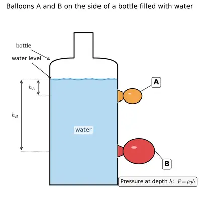
In Fig. 6.24, two identical (unstretched) balloons A and B are fixed at holes on the side of a bottle. Balloon A is at a higher position on the bottle, and balloon B is at a lower position — that is, A is at a smaller depth from the water surface, while B is at a greater depth.
When water is poured into the bottle, it pushes on the walls of the bottle in all directions. This side-ways push causes the water to press outward against both balloons.
1. Will both balloons bulge? Yes. Because a liquid exerts pressure on the walls of its container (and not only on the base), water pushes outward through both holes and inflates both balloons. So both A and B bulge outwards.
2. Will they bulge equally? No. The pressure of a liquid at a given depth $$h$$ below the free surface is $$P = h \rho g,$$ which increases with depth. Since balloon B is deeper below the water surface than balloon A ($$h_B > h_A$$), the water pushes on B harder than on A: $$P_B = h_B \rho g > h_A \rho g = P_A.$$
The balloon that is pushed harder stretches more. So the lower balloon B bulges more than the upper balloon A.
This activity nicely shows two important facts about liquid pressure:
- A liquid exerts pressure on the side walls (both balloons bulge), and
- The pressure of a liquid increases with depth (the lower balloon bulges more).
Answer
8 Explain how a storm becomes a cyclone.
Solution
A cyclone begins its life as a simple thunderstorm over a warm ocean and grows into a giant rotating storm system through the following steps.
1. Warm ocean water heats the air above it. When the sea surface is warm (usually above about $$27^{\circ}\mathrm{C}$$), a lot of water evaporates from it. The moist air above the sea becomes hot, less dense, and starts rising upward.
2. A low-pressure region forms. As this warm, moist air rises, it leaves behind a region of low pressure near the sea surface. Cooler, higher-pressure air from the surrounding areas rushes in horizontally to fill this low-pressure region — creating strong winds that blow towards the centre.
3. Condensation releases heat, feeding the storm. When the rising warm air reaches greater heights, it cools. The water vapour condenses into tiny water droplets, forming huge thunderclouds. Condensation of water vapour releases a large amount of heat (called latent heat) into the surrounding air. This extra heat warms the air even more and makes it rise even faster, pulling in more warm moist air from below. This is a self-strengthening cycle.
4. Earth's rotation makes the winds spin. Because the Earth is rotating, the winds rushing towards the low-pressure centre are deflected sideways instead of moving in straight lines. As a result, they start to spiral around the centre. This spinning motion is what changes an ordinary storm into a rotating cyclonic system.
5. The storm intensifies into a cyclone. As long as the system is over warm ocean water, it keeps drawing in energy from evaporation and condensation. The rotating winds grow stronger and stronger. When the wind speed at the centre exceeds about $$120 \, \mathrm{km/h}$$, the system is called a cyclone. It develops a well-defined structure with a calm central 'eye' surrounded by a ring of tall thunderclouds (the eye-wall) and vast spiral rain-bands.
Thus a small storm, fed by warm sea water and shaped by the Earth's rotation, grows into a cyclone.
Answer
9

Solution
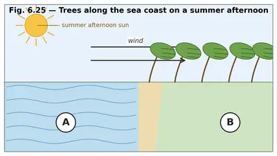
In Fig. 6.25, the trees on the sea coast are shown bent towards the side labelled A. Trees bend in the direction in which the wind is blowing, so the wind here is blowing from side B towards side A.
Now let us think about wind at the coast on a summer afternoon.
- Land heats up much faster than water. So on a hot summer afternoon, the land becomes much hotter than the sea.
- The air above the hot land becomes warm, less dense and rises upward. This creates a region of low air pressure over the land.
- The air above the sea is comparatively cooler and remains at a higher pressure.
- Since air flows from a region of high pressure to a region of low pressure, cool air from the sea blows towards the land. This is called the sea breeze.
Applying this to the figure. The wind (sea breeze) blows from the sea (high pressure) towards the land (low pressure). In Fig. 6.25 the wind is going from B towards A. Therefore B must be the sea side, and A must be the land side.
Answer
10 Describe an activity to show that air flows from a region of high pressure to a region of low pressure.
Solution
Activity — Inflating a balloon and letting the air out.
Materials required: a rubber balloon.
Steps:
- Take an empty balloon. The air inside the deflated balloon is at the same pressure as the room air (atmospheric pressure).
- Blow air into the balloon and pinch its mouth tightly with your fingers so that no air escapes. Because you have pushed extra air into a small volume, the pressure of the air inside the balloon is now higher than the atmospheric pressure outside.
- Now bring your face close to the mouth of the balloon and slowly release your fingers so that the balloon's opening is free.
Observation: A rush of air comes out of the balloon and you can clearly feel it on your face. The balloon deflates.
Interpretation: The air inside the balloon was at a higher pressure than the surrounding air. When the mouth was opened, the air flowed out of the balloon (high pressure) into the surrounding room (low pressure). This shows that air flows from a region of high pressure to a region of low pressure.
Alternative activity — Two connected balloons.
- Take two identical balloons. Blow up one of them fully (so it is at high pressure inside) and leave the other one only partially inflated (at lower pressure).
- Join their mouths together tightly using a short piece of rubber tube or straw with a clip, keeping the clip closed.
- Open the clip.
Observation: Air rushes from the fully-inflated balloon (higher pressure) into the smaller balloon (lower pressure) until the pressures inside the two balloons become equal. This again shows that air moves from a region of high pressure to a region of low pressure.
The same principle explains why winds blow in the atmosphere — from regions of high air pressure to regions of low air pressure.
Answer
11 What is a thunderstorm? Explain the process of its formation.
Solution
What is a thunderstorm?
A thunderstorm is a violent weather event in which tall, dark clouds produce lightning, thunder, strong winds and heavy rainfall (sometimes with hail). It is usually accompanied by rapid drops of ambient temperature and gusty winds.
The two key requirements for a thunderstorm are: (i) plenty of moisture in the air, and (ii) strong upward winds that can carry this moist air to great heights.
Process of formation.
Step 1 — Heating of the surface. On a hot day, the Sun heats up the ground and the water bodies. The land and water get warm, and so does the air just above them. A lot of water also evaporates, making the air moist.
Step 2 — Rising of warm, moist air. Warm moist air is less dense than the cooler air around it. So this warm air rises rapidly through the atmosphere, forming a strong updraft. As it rises, cooler air rushes in from the surroundings — creating strong winds near the ground.
Step 3 — Condensation and formation of clouds. High up in the atmosphere, the temperature is much lower. The rising air cools down, and the water vapour it carries condenses into tiny water droplets. Huge, tall thunderclouds (called cumulonimbus clouds) begin to build up.
Step 4 — Release of latent heat. When water vapour condenses, it releases a large amount of heat (called latent heat) into the surrounding air. This makes the air even warmer, so the updraft becomes still stronger and even more moist air is drawn upward.
Step 5 — Rubbing of ice particles and separation of charges. Inside the tall clouds, water droplets freeze into tiny ice particles at higher and colder levels. Powerful updrafts and downdrafts inside the cloud make these ice particles and water droplets rub against one another. This friction causes electric charges to develop — positive charges collect near the top of the cloud and negative charges near its base.
Step 6 — Discharge — lightning, thunder and rain. When the charge separation becomes very large, the huge voltage forces air to break down along a narrow path and a bright electric discharge (lightning) flashes between the clouds or between the cloud and the ground. Air along this path is heated to very high temperatures and expands explosively, producing the loud sound we call thunder. Meanwhile, water droplets grow big enough to fall as heavy rain, often together with strong gusty winds.
All this together is what we experience on the ground as a thunderstorm.
Answer
12 Explain the process that causes lightning.
Solution
Lightning is a huge, brief electric discharge (a giant spark) in the sky. It occurs inside a cloud, between two clouds, or between a cloud and the ground. It is caused by a large build-up of electric charges in thunderclouds. The process happens in the following stages.
Stage 1 — Growth of a tall thundercloud. On a hot day, warm moist air rises rapidly from the Earth's surface and forms a very tall thundercloud (cumulonimbus). Inside this cloud, powerful winds move both upwards and downwards.
Stage 2 — Formation of ice particles. The upper parts of the cloud are so cold that water droplets freeze into tiny ice particles. The lower parts of the cloud still contain many water droplets.
Stage 3 — Rubbing of ice particles and water droplets. The strong updrafts and downdrafts inside the cloud make the ice particles and water droplets collide and rub against each other continuously. This rubbing is exactly like rubbing a plastic comb through your hair — it produces electric charges by friction.
Stage 4 — Separation of charges. The upper (colder) part of the cloud becomes positively charged, while the lower part becomes negatively charged. Because of the induction effect, the ground below the cloud becomes positively charged. So there is a huge accumulation of opposite charges — negative at the bottom of the cloud and positive on the ground (or in a neighbouring cloud).
Stage 5 — Air breakdown and discharge. Air is normally a poor conductor of electricity, so at first these charges cannot flow between the cloud and the ground. As the charges keep piling up, the voltage between them becomes very large. Eventually the voltage is so huge that it forces the air along a narrow path to break down and conduct electricity briefly. A very strong current flows for a small fraction of a second — a bright flash of lightning.
Stage 6 — Thunder. The air along the lightning path is heated to tens of thousands of degrees within an instant. It expands violently, producing a loud shock wave that we hear as thunder. We see the flash first and hear the thunder a little later because light travels much faster than sound.
In short, the collision and friction of ice particles and water droplets in tall clouds produce a large separation of electric charges; when the charge becomes big enough to break down the air between the cloud and the ground (or between two clouds), the charges flow suddenly as a giant electric spark — that is lightning.
Answer
13 Explain why holes are made in banners and hoardings.
Solution
Big banners and hoardings put up on roads, buildings and open grounds have a large surface area facing the air. When wind blows against such a wide flat surface, the moving air pushes on it. This push is a force acting on an area, i.e. a pressure.
The force on the banner is $$F = P \times A,$$ where $$P$$ is the pressure exerted by the wind and $$A$$ is the area of the banner. Since the area $$A$$ is very large, even a moderate wind pressure produces a very large force on the banner. This strong force can:
- make the banner flap violently and get torn,
- uproot the poles or frame supporting it, or
- make the banner fly off and injure people passing below.
What holes do. When several holes are made in the banner, the wind blowing against it does not have to push the entire area — it simply passes through the holes. So the effective area on which the wind pushes becomes much smaller. From $$F = P \times A$$, a smaller area means a smaller force on the banner. Also, the air is no longer forced to go around the whole banner, so much less thrust is produced.
Thus the holes reduce the wind force on the banner, so it does not get torn or blown away and its supporting structure remains safe. This is why banners and hoardings, especially the large ones displayed outdoors, always have many round holes cut into them.
Answer
Discover, design, and debate
1 Hold a strip of paper, 18 cm long and 2 cm wide, between your thumb and forefinger so that it hangs freely. Predict what you will observe if you blow over the paper. Perform the activity now. Note down your observations and interpret your results.
Solution
Setting up the activity. Take a rectangular strip of paper about $$18 \, \mathrm{cm}$$ long and $$2 \, \mathrm{cm}$$ wide. Hold one short end of the strip between your thumb and forefinger and let the rest of the strip hang down freely in front of your mouth.
Prediction. Since I am blowing air above the paper, my first guess might be that the paper would be pushed downward. This is the intuitive prediction most students make.
Observation. When I blow steadily along the top surface of the paper, the free end of the paper does not go down. In fact, it rises up towards the direction in which I am blowing, so that the paper becomes almost horizontal in the air stream. As soon as I stop blowing, the paper falls back to its original hanging position.
Interpretation. The result seems surprising, but it can be explained using the idea that fast-moving air has lower pressure than still air.
- The still air below the paper is at normal atmospheric pressure $$P_1$$.
- The air I blow above the paper is moving fast, so its pressure $$P_2$$ is less than $$P_1$$, i.e. $$P_2 < P_1$$.
Because the pressure below the paper is now larger than the pressure above it, the paper is pushed upward by a net force $$F = (P_1 - P_2) \times A,$$ where $$A$$ is the area of the paper. This upward push is what lifts the free end of the paper.
Conclusion. The activity shows that when the air over one side of an object moves fast, the pressure there decreases. The bigger pressure on the other side then pushes the object towards the moving-air side. This is the same principle that helps aeroplane wings generate lift, and it is one of the reasons roofs sometimes get blown off during cyclonic winds (fast winds blowing over the roof reduce the pressure above, and the higher pressure inside the house pushes the roof upwards).
Answer
2 List three major cyclones which have occured in India in the last 20 years. List two major destruction caused by each of the cyclones. What measures were taken by the local government and communities to reduce the loss of life and destruction of property? Mention two suggestions you would like to propose to the local government.
Solution
Note. This is a project-type question. The following is a model answer based on three well-documented cyclones that struck the Indian coast in the past two decades.
Three major cyclones in India (last 20 years).
| Cyclone | Year | Region badly hit | Two major kinds of destruction |
|---|---|---|---|
| Cyclone Phailin | 2013 | Odisha and Andhra Pradesh coasts | (i) Very heavy rain and storm surge flooded low-lying coastal villages and paddy fields, damaging crops on lakhs of hectares. (ii) Extremely strong winds (up to about $$220 \, \mathrm{km/h}$$) uprooted trees and electric poles and destroyed thousands of thatched and semi-pucca houses. |
| Cyclone Fani | 2019 | Odisha coast, especially Puri | (i) High-speed winds and flying debris damaged houses, schools and power lines, cutting off electricity and communication in many areas. (ii) Storm surge and flooding damaged fishing boats, drinking-water systems and hospitals; several lives were also lost. |
| Cyclone Amphan | 2020 | West Bengal and Odisha coasts | (i) Winds over $$180 \, \mathrm{km/h}$$ and heavy rain flattened houses, uprooted thousands of trees and damaged parts of Kolkata city severely. (ii) Salt-water intrusion from the storm surge damaged farmland, ponds and drinking-water sources in the Sundarbans region. |
Measures taken by the local government and communities.
- The India Meteorological Department (IMD) tracked each cyclone and issued regular warnings and colour-coded alerts well in advance.
- The state governments and the National Disaster Response Force (NDRF) evacuated lakhs of people from the low-lying coastal villages to safer inland places before the cyclones made landfall.
- Cyclone shelters, schools and community halls were opened to house the evacuees, and food, drinking water, first aid and medicines were arranged.
- Fishermen were warned not to venture into the sea; ports and airports were closed; trains and buses in the affected area were suspended.
- Electricity, telephone lines and other utilities were shut down beforehand to prevent electrocution and fires.
- After the cyclone, the government carried out rescue and relief operations — restoring roads, power lines and water supply, and giving compensation to the affected families.
Two suggestions I would like to propose to the local government.
- Build more permanent cyclone shelters and strengthen weak houses. In every coastal village, sufficient number of strong concrete cyclone shelters should be built at safe, elevated locations. The government should also help poor families upgrade thatched houses to safer designs with reinforced roofs and shutters.
- Prepare people through awareness and drills. Local authorities should conduct regular cyclone-preparedness drills in schools and villages so that people know evacuation routes, safe places, and what to keep in an emergency kit. Early-warning messages should be sent in the local language through mobile SMS, television, radio, loudspeakers and community volunteers so that they reach even the most remote coastal families in time.
Answer
3 Collect data on the strength of thunderstorms for various regions of India. Compare your findings and identify which regions are more prone to thunderstorms. Can you give reasons for your findings?
Solution
Note. This is a project-type question. The following is a model answer based on information from the India Meteorological Department (IMD) and standard textbooks. You should verify and update the numbers by looking at the latest data on the IMD website.
Approximate number of thunderstorm days per year in different regions of India.
| Region of India | Approximate thunderstorm days per year | Strength |
|---|---|---|
| North-eastern states (Assam, Meghalaya, Arunachal Pradesh, Tripura, etc.) | 75 – 100 or more | Very frequent and severe (violent 'Kalbaisakhi' thunderstorms in pre-monsoon months) |
| Eastern India (West Bengal, Odisha, Jharkhand, Bihar) | 50 – 80 | Very frequent, often severe |
| Central India (Chhattisgarh, Madhya Pradesh) | 40 – 60 | Frequent, moderate to severe |
| Southern peninsula (Kerala, Tamil Nadu interior, Karnataka) | 30 – 60 | Frequent, mainly in pre-monsoon and monsoon seasons |
| Western plains (Rajasthan, Gujarat, western Maharashtra) | 10 – 30 | Occasional |
| North-western Himalayan states (Jammu & Kashmir, Ladakh, Himachal Pradesh) | 10 – 25 | Occasional |
Findings.
- The north-eastern states (especially Meghalaya, Assam, Arunachal Pradesh and Tripura) and the eastern states (West Bengal, Odisha, Jharkhand, Bihar) are the most prone to thunderstorms in India.
- The western and north-western regions (Rajasthan, Gujarat, Ladakh) experience the fewest thunderstorms.
- The southern peninsula shows a moderate to high number of thunderstorm days, more concentrated in the pre-monsoon (April–May) and monsoon months.
Reasons for the findings.
Thunderstorms need two conditions: (i) plenty of moisture in the air and (ii) strong upward winds that lift this moist air to great heights, where it cools and forms tall thunderclouds.
- The north-east and east lie close to the warm Bay of Bengal and are covered with dense forests and river systems. So the air here is highly moist. Heating during the pre-monsoon summer months makes this moist air rise very fast, causing frequent severe thunderstorms (the famous Kalbaisakhi / Nor'westers).
- The southern peninsula is surrounded on three sides by warm seas, so plenty of moist air is available; strong afternoon heating produces frequent thunderstorms, particularly before and during the monsoon.
- The north-western states (Rajasthan, Gujarat) are largely dry and desert-like. The air there has very little moisture, so thunderstorms are few and far between. The Ladakh region is a cold desert; even though it has strong heating, it lacks moisture.
Conclusion. The regions of India that are closest to warm oceans and are rich in moisture (especially the north-east and east) experience the most frequent and most powerful thunderstorms, while the dry western and north-western regions experience very few. This confirms that availability of moisture, together with strong surface heating, is the key factor in deciding how prone a region is to thunderstorms.
Answer