Geography Questions for CMAT PDF
Download CMAT 2022 Geography Questions PDF by Cracku. Very Important Geography Questions for CMAT 2022 based on asked questions in previous exam papers. These questions will help your CMAT preparation. So kindly download the PDF for reference and do more practice.
Download Geography Questions for CMAT
Take CMAT mock tests here
Download CMAT previous papers PDF
Question 1: The civilian Airport of highest altitude is in …… .
a) Tibet
b) Nepal
c) India
d) China
Question 2: Of the following man-made disasters, which is socially induced ?
a) Debris Avalanche
b) Salt Water Intrusion
c) Arson
d) Ozone depletion
Question 3: The seat of intelligence is situated in the
a) cerebrum
b) cerebellum
c) medulla
d) thalamus
Question 4: Which location does not have an oil refinery ?
a) Numaligarh
b) Kochi
c) Panipat
d) Agra
Question 5: Black soil is not found in
a) Tamil Nadu
b) Maharashtra
c) West Bengal
d) Andhra Pradesh
Get 5 CMAT mocks at just Rs.299
Download CMAT Previous Papers PDF
Question 6: What percentage of area is the area of Rajasthan in India ?
a) 10.4%
b) 10.6%
c) 10.8%
d) 10.9%
Question 7: Name the Indian state having maximum number of Major Seaports.
a) West Bengal
b) Goa
c) Gujarat
d) Tamil Nadu
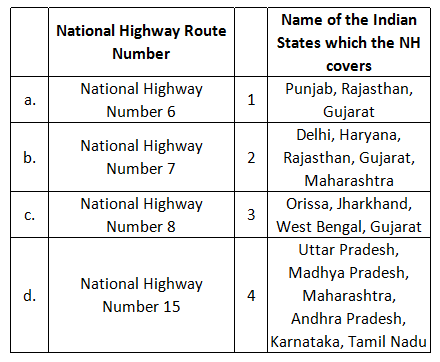
Question 8: Match the National Highway route number to States that it covers?
a) a-4, b-2, c-1, d-3
b) a-2, b-3, c-4, d-1
c) a-3, b-4, c-2, d-1
d) a-4, b-1, c-2, d-3
Question 9: Match the Country, City and River.

a) a-i-3, b-iv-1, c-iii-2, d-ii-4
b) a-iii-1, b-iv-3, c-i-4, d-ii-2
c) a-iv-4, b-iii-1, c-i-2, d-ii-3
d) a-iii-4, b-iv-1, c-i-3, d-ii-2
Question 10: Match the Geographical Epithet to Country/ City.

a) a-1, b-4, c-3, d-2
b) a-4, b-3, c-2, d-1
c) a-3, b-1, c-4, d-2
d) a-1, b-2, c-4, d-3
Question 11: Which one of the following national park established by government of India is the relatively the latest one?
a) Madhav National Park, Madhya Pradesh
b) Khangchendzonga National Park, Sikkim
c) Corbett National Park, Uttaranchal
d) Tadoba National Park, Maharashtra
Question 12: Which of the following rivers do not flow across Uttarakhand?
a) Bhagirathi and Ganga
b) Ramaganga and Yamuna
c) Gandak and Gomti
d) Tons and Tilak
Question 13: What is a good estimate for the length of the coastline of the mainland India?
a) 6000 kms.
b) 7500 kms.
c) 9000 kms.
d) 11,000 kms.
Question 14: When it is 11:15 as per Greenwich Mean Time, what will be the time in Delhi
a) 04:45 hours
b) 05:45 hours
c) 17:45 hours
d) 16:45 hours
Question 15: Mullaperiyar Dam is a matter of controversy between which of the following states?
a) Karnataka – Tamil Nadu
b) Kerala – Tamil Nadu
c) Kerala – Karnataka
d) Karnataka – Andhra Pradesh
Question 16: Arrange the following Indian rivers from North to South
1. Narmada
2. Kaveri
3. Jhelum
4. Godavari
a) 3 – 1 – 2 – 4
b) 1 – 4 – 3 – 2
c) 1 – 3 – 4 – 2
d) 3 – 1 – 4 – 2
Question 17: Mt. Everest is the highest mountain summit of the world. Rank the following summits in descending order of their heights?
i. Makalu;
ii. Kanchenjunga;
iii. Godwin Austen;
iv. Lhotse
a) iv-i-iii-ii
b) ii-iii-i-iv
c) iii-ii-iv-i
d) i-iv-ii-iii
Question 18: Which country has the longest coastline
a) USA
b) Australia
c) India
d) Canada
Question 19: Arrange the following Indian port cities beginning from East to West.
i. Jamnagar
ii. Kochi
iii. Chennai
iv. Visakhapatnam
a) i-ii-iii-iv
b) iv-iii-ii-i
c) ii-iv-i-iii
d) iii-i-iv-ii
Question 20: Which of the following cities is at the junction of the highways known as North-South and East- West Corridors?
a) Delhi
b) Nagpur
c) Jhansi
d) Hyderabad
Answers & Solutions:
1) Answer (D)
The civilian Airport of the highest altitude is in China. It is located at an elevation of 4,411m.
2) Answer (C)
Arson is socially induced man-made disasters among the given options.
3) Answer (A)
Cerebrum is the Part of brain which is also known as seat of intelligence, the prefrontal cortex (PFC) is the cerebral cortex which covers the front part of the frontal lobe. The prefrontal cortex is in charge of abstract thinking and thought analysis, it is also responsible for regulating behaviour.
4) Answer (D)
Numaligarh oil refinery is located in Assam.
BPCL Kochi oil refinery is located in Kerala.
Panipat oil refinery is located in Haryana.
In Agra, there is not any oil refinery.
5) Answer (C)
Black soil found in Gujarat, Madhya Pradesh, Tamil Nadu, Andhra Pradesh, Karnataka and Maharashtra. Laterite soil found in West Bengal.
6) Answer (A)
10.41% of area is the area of Rajasthan in India. The state has 342,239 square kilometres.
7) Answer (D)
Tamil Nadu has the maximum number of major sea ports.
Hence, option D is the correct answer.
8) Answer (C)
This question is based on the old numbering of National Highways in India.
NH6 runs through Gujarat, Maharashtra, Chhattisgarh, Odisha, Jharkhand and West Bengal state in India.
National Highway 7 or NH 7, is major North-South National Highway in India that runs through the states of Uttar Pradesh, Madhya Pradesh, Maharashtra, Telangana, Andhra Pradesh, Karnataka, and Tamil Nadu.
National Highway 8 is the busiest highway in the subcontinent, as it connects the national capital Delhi to the financial capital Mumbai, as well as important cities Gurgaon, Jaipur, Ajmer, Udaipur, Ahmedabad, Vadodara and Surat.
NH 15 runs through Pathankot – Amritsar – Tarn Taran Sahib – Bhatinda – Ganganagar – Bikaner – Jaisalmer – Barmer – Samakhiali (Punjab, Rajasthan and Gujarat)
Hence, option C is the correct answer.
9) Answer (D)
Warsaw is the capital of Poland.
Lisbon is the capital of portugal.
Chittagong is in Bangladesh.
Dresden is in Germany.
Hence, option D is the correct answer.
10) Answer (C)
Budapest is known as Twin City.
Chicago is known as Windy City.
Philadelphia is known as Quaker City.
Belgrade is known as White City.
Hence, option C is the correct answer.
11) Answer (B)
Madhav National Park, Madhya Pradesh was established in 1958.
Khangchendzonga National Park, Sikkim was established in 1977.
Corbett National Park, Uttaranchal was established in 1936.
Tadoba National Park, Maharashtra was established in 1955.
Hence, option B is the correct answer.
12) Answer (C)
Gandak and Gomti rivers do not flow across Uttarakhand.
Hence, option C is the correct answer.
13) Answer (A)
Gujarat is strategically located with largest share in India’s coastline, followed by Andhra Pradesh and Tamil Nadu.
State Coastline
Gujarat 1915.29
Andhra Pradesh 1037
Tamil Nadu 864.73
Kerala 560
Maharashtra 510.31
Orissa 457.2
West Bengal 374
Karnataka 258.15
Goa 113.03
Total – 6089.71 . Hence, option A is the correct answer.
14) Answer (D)
IST = GMT + 5:30. Hence, when GMT = 11:15 Then IST = 5:30 + 11:15 = 16 : 45.
15) Answer (B)
The Mullaperiyar Dam or Mullaiperiyar Dam is a masonry gravity dam on the Periyar River in the Indian state of Kerala. It is located 881 m (2,890 ft) above mean sea level, on the Cardamom Hills of the Western Ghats in Thekkady, Idukki District of Kerala, South India. It was constructed between 1887 and 1895 by John Pennycuick and also reached in an agreement to divert water eastwards to the Madras Presidency area (present-day Tamil Nadu). It has a height of 53.6 m (176 ft) from the foundation, and a length of 365.7 m (1,200 ft).The Periyar National Park in Thekkady is located around the dam’s reservoir. The dam is located in Kerala on the river Periyar, but is operated and maintained by Tamil Nadu state. Although the Periyar River has a total catchment area of 5398 $km^2$ with 114 $km^2$ in Tamil Nadu, the catchment area of the Mullaperiyar Dam itself lies entirely in Kerala.
16) Answer (D)
The Jhelum River, is a river of west Kashmir and eastern Pakistan. It is the westernmost of the five rivers of Punjab, and passes through Srinager District. It is a tributary of the Indus River and has a total length of about 725 kilometres (450 mi).
The Narmada, also called the Rewa and previously also known as Nerbudda, is a river in central India after the Godavari, and the Krishna. It is also known as “Life Line of Gujarat and Madhya Pradesh” for its huge contribution to the state of Gujarat and Madhya Pradesh in many ways.
The Godavari is India’s second longest river after the Ganga. Its source is in Triambakeshwar, Maharashtra. It flows east for 1,465 kilometres (910 mi) draining the states of Maharashtra (48.6%), Telangana (18.8%), Andhra Pradesh (4.5%), Chhattisgarh (10.9%), Madhya Pradesh (10.0%), Odisha (5.7%), Karnataka (1.4%) and Puducherry (Yanam) and emptying into Bay of Bengal through its extensive network of tributaries.
Kaveri, also referred as Ponni, is an Indian river flowing through the states of Karnataka and Tamil Nadu. It is the third largest after Godavari and Krishna in south india and the largest in Tamil Nadu which on its course, bisects the state into North and South.
Hence, option D is the correct answer.
17) Answer (C)
Makalu – 8,481 m
Kanchenjunga – 8,586 m
Godwin Austen – 8,611 m
Lhotse – 8,516 m
Hence, option C is the correct answer.
18) Answer (D)
Canada has the longest coastline – 202,080 km.
19) Answer (B)
Visakhapatnam (Andhra Pradesh) is the most eastern port where as Jamnagar (Gujarat) is the most western port. Kochi is south of Jamnagar whereas Chennai is in the South-East direction. Therefore, from east to west -> Visakhapatnam, Chennai, Kochi, Jamnagar.
20) Answer (C)
Jhansi is at the junction of the highways known as North-South and East-West Corridors.


